For decades, getting a clear picture of a roof, a tower, a job site, or a sprawling commercial property meant ladders, lifts, scaffolding, helicopters, or a survey crew walking the ground for days. Those methods still exist, but in most cases a drone now does the same job faster, safer, and for a fraction of the cost — while giving you better data. This page makes the honest case for drones over traditional methods, addresses the objections people raise, and explains the legal and insurance basics so Chicago property owners, contractors, and facility managers can decide with confidence.
The Core Argument: Better Data, Less Risk, Lower Cost
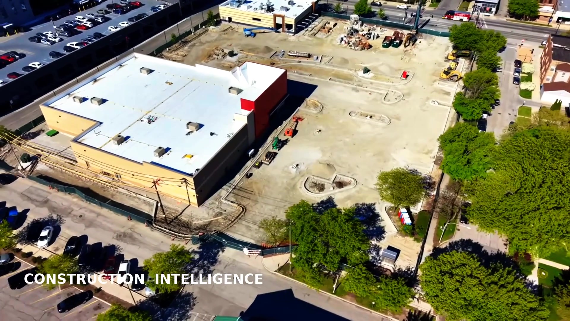
A drone is really three tools in one: a flying camera, a precise measuring instrument, and a thermal sensor. From a single short flight over a property in the Loop, Naperville, or anywhere across Chicagoland, an FAA Part 107 pilot can produce broadcast-quality video, centimeter-accurate maps and 3D models, and radiometric heat readings. Doing that the old way would take several specialists, several days, and several pieces of expensive equipment. The drone collapses all of that into one efficient visit.
That efficiency is not just about convenience. It changes what you can afford to do. When documenting a site is cheap and fast, you can do it monthly instead of once a year, catch problems earlier, and keep a visual record that protects you in disputes. Better data at a lower price means better decisions.
Cost: Stop Paying for Equipment and Downtime
Traditional inspection and documentation methods carry hidden costs. A boom or scissor lift has to be rented and delivered. Scaffolding takes a crew to assemble and tear down. A helicopter charter for aerial photography runs into the thousands per hour. A ground survey ties up a crew for days. Every one of those line items disappears or shrinks with a drone.
- No equipment rental — the aircraft is the equipment, and it fits in a case.
- No crew setup time — one pilot deploys in minutes, not hours.
- Less operational downtime — a roof, parking deck, or facade can be documented without shutting down the area below.
- Fewer return trips — a drone captures the whole site in one pass, so you rarely pay twice.
For a side-by-side breakdown of the math on specific jobs, see our comparisons of drone inspection vs lift inspection and drone mapping vs traditional surveying.
Speed: Hours Instead of Days
Time is the cost people forget. A drone can map a 10-acre site or photograph a 12-story building in a single flight window. There is no scaffold to build, no lift to position, no crew to schedule around. In a market like Chicago, where a delayed listing or a stalled inspection can cost real money, the ability to deploy quickly and deliver in 24 to 48 hours is a genuine advantage. Faster capture also means a tighter feedback loop — you see the problem, fix it, and re-fly to confirm, all in the same week.
Safety: Nobody Has to Climb
This is the argument that wins over most facility managers and contractors. The most dangerous part of a traditional inspection is putting a human on a ladder, a steep roof, a tower, or a lift basket. Falls remain one of the leading causes of serious injury in construction and maintenance work. A drone keeps the pilot on the ground. There is no scaffolding to fail, no lift to tip, no roof edge to slip from. You get a closer, more thorough look at the dangerous areas precisely because no one has to risk reaching them. For roof and envelope work specifically, our thermal inspection and roof inspection vs manual inspection pages go deeper on the safety case.
Access: See What People Can't Reach
Some vantage points are simply impossible from the ground. The center of a large flat roof, the underside of a high cornice, the far end of an active job site, the full footprint of a property line — a drone reaches all of them effortlessly. In dense Chicago neighborhoods like River North or the West Loop, where setting up a lift on a busy street is impractical, aerial access is often the only practical option. The drone goes where a person can't, and brings back imagery sharp enough to count shingles or read a crack.
Data Richness: From Pictures to Measurements
A photo tells you something looks wrong. Drone data tells you how wrong, where, and by how much. With overlapping imagery and ground control points, we produce geo-referenced orthomosaic maps and 3D models and digital twins you can measure inside — distances, areas, volumes, elevations. Radiometric thermal imagery records actual temperatures, turning a vague "the roof feels warm" into a mapped moisture problem with numbers attached. That measurable output is what makes drone work defensible in front of investors, insurers, and courts.
Frequency: Document More Often, Catch Problems Early
Because each capture is cheap and fast, you can repeat it on a schedule. Monthly construction progress flights, quarterly roof checks, or recurring multi-site inspections become realistic instead of luxuries. Frequent documentation means small issues get caught before they become expensive failures, and you build a time-stamped visual history that settles disputes and supports warranty and insurance claims. This is the foundation of our construction documentation and enterprise programs.
Better Marketing and Stronger Storytelling
Beyond inspection and measurement, drones simply make properties and projects look their best. Aerial photography and 4K video give real estate listings, developments, and brands a perspective the ground can't match — context, scale, and motion that hold attention. Listings with aerial media tend to draw more clicks and faster interest. See aerial photography and real estate media for how we turn altitude into engagement.
ROI: Where the Value Actually Shows Up
Put the pieces together and the return is clear. You spend less on equipment and labor, you finish in hours instead of days, you avoid injury risk and the costs that follow it, you catch defects early when they're cheap to fix, and you market more effectively. A single drone deliverable often pays for itself by preventing one missed defect, one stalled closing, or one safety incident. That is why owners and contractors across Chicagoland are making aerial data a standard line item rather than a novelty.
Honest Answers to Common Objections
"Is it legal?"
Yes, for certified operators. Commercial drone flight is governed by FAA Part 107, which requires a licensed Remote Pilot in Command. Chicago Drone Service is Part 107 certified, and we file LAANC authorizations to fly legally inside the controlled airspace around O'Hare and Midway and around downtown restrictions.
"What about my privacy and my neighbors?"
We fly only over the property we're hired to document, keep the camera trained on the subject site, and brief the flight plan in advance. We avoid capturing neighboring properties unnecessarily and follow FAA and local guidance throughout.
"Chicago weather is unpredictable."
True — which is exactly why a quick-to-deploy tool helps. We monitor wind, precipitation, and visibility, and reschedule when conditions would hurt safety or quality. Because setup is minutes, finding a clear window is usually easy.
"Can I trust the accuracy?"
With proper planning and ground control points, drone maps and models are measurable to within a few centimeters, and radiometric thermal records real temperature values. To understand the terms behind those numbers, visit our drone knowledge center.
Legality and Insurance, Plainly Stated
Every commercial flight we operate is flown under FAA Part 107 by a certified Remote Pilot in Command. We carry liability insurance and can provide a certificate of insurance for your project, building, or campus when required. Where airspace is controlled, we secure LAANC authorization before we fly. This combination — certification, insurance, and airspace compliance — is what separates a professional operator from a hobbyist and is essential for any serious commercial work in Chicago. To learn more about who we serve and where we fly, see industries we serve and areas we serve.
The Bottom Line for Chicago
Traditional methods aren't obsolete — there are still moments when hands-on access or a full survey crew is the right call. But for the vast majority of inspection, documentation, mapping, and marketing needs, a drone wins on cost, speed, safety, access, and data quality at the same time. That's a rare combination, and it's why aerial data has moved from "nice to have" to "how it's done" across Chicagoland.
Ready to see what a drone can do for your property or project?
Request a Free QuoteOr call us directly at 847-881-4344 to talk through your project with an FAA Part 107 certified pilot.