Drone services come with a lot of jargon — Part 107, LAANC, GSD, orthomosaic, photogrammetry, radiometric thermal. This knowledge center explains the concepts behind professional aerial work in plain everyday language for Chicago property owners, builders, agents, and facility managers trying to decide whether a drone is the right tool for a job. Whether you are weighing a roof inspection, a site map, a 3D model, or a marketing shoot across Chicagoland, the goal is simple: give you the vocabulary to ask the right questions and get the right deliverable.
Chicago Drone Service is operated by Dan Gierke, an FAA Part 107 Remote Pilot in Command. Everything below reflects how we actually plan and fly jobs across Chicago, Cook, DuPage, Lake, Will, and Kane Counties.
What Is FAA Part 107?
FAA Part 107 is the federal rule set that governs commercial drone flight in the United States. Any time a drone is flown for a business purpose or for pay, it falls under Part 107, and the person at the controls must hold a current FAA Part 107 Remote Pilot certificate. Earning that certificate means passing an FAA aeronautical knowledge exam covering airspace, weather, regulations, and safe operations.
Why does this matter to you? Hiring an uncertified operator for commercial work is a compliance risk, and it usually means flying without proper insurance or airspace authorization. A certified, insured pilot protects your project, your property, and your liability. If you want the broader case for choosing drones over traditional methods, see why drones.
LAANC & Controlled Airspace (O'Hare & Midway)
Airspace in the United States is layered, and a large share of Chicago sits inside controlled airspace because of O'Hare International and Midway International airports. You cannot legally fly a drone in that controlled airspace without authorization. LAANC — Low Altitude Authorization and Notification Capability — is the FAA system that grants near-instant approval to fly up to defined altitude ceilings in many of these zones.
A local Chicago pilot knows where the altitude grids tighten downtown, near the lakefront, and around the airports, and requests LAANC authorization before arriving on site. That airspace fluency is one of the biggest practical differences between a hobbyist and a professional operator — it is the difference between a flight that happens and one that gets grounded.
Orthomosaic vs. a Single Aerial Photo
A single aerial photo is one viewpoint from one moment — great for marketing, not for measuring. An orthomosaic map is built from hundreds of overlapping images that are geometrically corrected and stitched into one seamless, top-down, geo-referenced image. Because the distortion is removed and the result is tied to a real coordinate system, every point is to scale. That lets you measure distances and areas, overlay the map in GIS or CAD, and track a site over time.
- Photo — looks good, can't be measured reliably, no coordinate system.
- Orthomosaic — measurable, geo-referenced, exportable to AutoCAD/GIS, repeatable for progress tracking.
Photogrammetry & 3D Digital Twins
Photogrammetry is the science of building accurate measurements and models from photographs. By capturing a structure or site from many overlapping angles, software reconstructs a precise 3D representation. The result can be a textured mesh, a point cloud, or a full 3D digital twin — a measurable, navigable digital copy of a real building or site.
Architects use digital twins for existing-conditions documentation, contractors use them for coordination and dispute resolution, marketers use them for immersive presentations, and insurers and asset owners use them for records. The key advantage is that a good model is not just a picture — you can take measurements directly from it.
Radiometric Thermal & Infrared
Thermal (infrared) imaging captures heat instead of visible light. A radiometric thermal sensor records an actual temperature value for every pixel, not just a false-color picture, which means anomalies can be quantified rather than guessed. From the air, that is a powerful way to find problems that are invisible to the naked eye.
- Roof moisture — trapped water holds heat and shows up as warm signatures after sunset.
- Building envelope — heat loss, missing insulation, and air leaks become visible patterns.
- Solar panels — failing cells and strings appear as hotspots across an array.
- Electrical & mechanical — overheating components stand out before they fail.
Learn how we apply this in the field on the thermal drone inspections page.
GSD, Resolution & Accuracy
GSD stands for Ground Sample Distance — the real-world size each pixel represents on the ground. A GSD of 1 cm/pixel means one pixel covers one centimeter. Smaller GSD equals more detail and the potential for higher accuracy. GSD is driven mainly by flight altitude and camera quality: fly lower and the GSD shrinks.
It is worth separating two ideas. Relative accuracy is how correct measurements are within the model. Absolute accuracy is how correctly the model is positioned in the real world. Marketing visuals can fly higher with a larger GSD; survey-grade deliverables need a small GSD plus control points (below).
Ground Control Points (GCPs)
Ground control points are marked targets placed around a site with precisely surveyed coordinates. During processing, those known points anchor the orthomosaic or 3D model to the real world, sharpening absolute accuracy to within centimeters when the job demands it. For volumetrics, engineering, and surveying-adjacent work, GCPs are what elevate a map from "looks right" to "measures right."
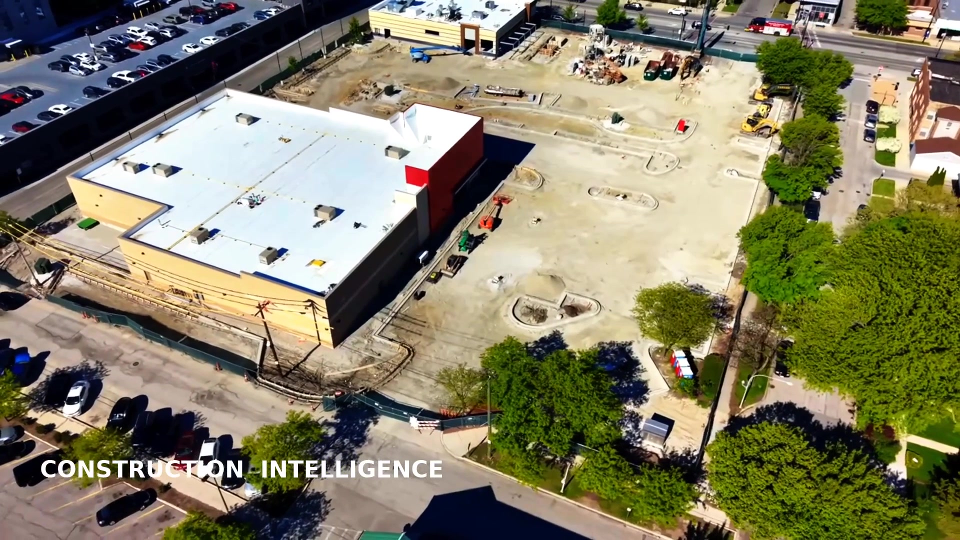
Volumetrics
Volumetric analysis uses drone data to calculate volumes — stockpiles of gravel, sand, or soil; cut-and-fill on a grading project; or material moved between site visits. Because the calculation comes from an accurate 3D surface, you get fast, repeatable measurements without sending people to climb or walk a pile. On active Chicago job sites, this supports inventory tracking and earthwork verification. See how it ties into construction documentation.
Deliverable Formats
Knowing the output you need helps scope the flight. Common deliverables include:
- Photos & 4K video — JPG, PNG, MP4 for marketing and records (see aerial photography).
- Orthomosaics — GeoTIFF and PDF maps for planning and measurement.
- 3D models — OBJ, point clouds (LAS/LAZ), and web-viewable digital twins.
- Thermal reports — annotated radiometric imagery with findings.
- CAD/GIS exports — DXF/DWG and georeferenced layers for design software.
How to Prepare a Site
A little prep produces noticeably better results. Share the property address and any access notes, flag rooftop, parking, or security considerations, and tell us the goal of the flight. We handle the airspace checks and LAANC authorizations. On flight day, clearing vehicles or equipment from the target area, securing pets, and choosing a window with calm wind and good light help us capture clean, usable data the first time.
Insurance & Safety
Professional drone work should be both insured and methodical. We carry liability coverage and fly with pre-flight checklists, airspace authorization, and weather minimums. Aerial inspection also removes people from dangerous positions — no climbing roofs, no scaffolding, no boom lifts — which is safer for everyone and often faster, too. For a fuller comparison of the safety upside, read why drones.
How to Hire a Drone Pilot in Chicago
When you evaluate an operator, confirm a few essentials: a current FAA Part 107 certificate, proof of insurance, comfort with LAANC and Chicago's controlled airspace, and a clear description of the exact deliverable you will receive. Ask to see relevant work and confirm turnaround times. A good local pilot will translate your goal into the right capture plan — the right altitude, GSD, overlap, and control — rather than just "flying the drone."
Chicago Drone Service checks every one of those boxes and serves the entire region. Explore where we operate on areas we serve, or start a project on the request a quote page.
Comparison Guides
Deciding whether a drone is the right tool for your project? These side-by-side guides walk through the real trade-offs on cost, safety, speed, and accuracy so you can choose the right approach before you hire anyone.
- Drone Inspection vs. Lift Inspection — compares aerial drone access to boom lifts and scaffolding for high or hard-to-reach structures on cost, OSHA safety, downtime, and turnaround speed.
- Drone Mapping vs. Traditional Surveying — breaks down when drone orthomosaics and 3D models outperform conventional survey crews on speed, cost, accuracy, and volumetric reporting.
- Drone Roof Inspection vs. Manual Inspection — compares aerial and thermal drone roof inspections to on-roof manual inspections across safety, thoroughness, cost, and inspection frequency.
- Thermal Drone Inspection vs. Handheld Infrared — explains when aerial radiometric thermal imaging beats a ground-based handheld camera for large-area coverage, roof access, moisture detection, and scale.
Frequently Asked Questions
Do I need FAA Part 107 to hire a drone pilot in Chicago?
You don't need a certificate yourself, but the pilot you hire should hold an FAA Part 107 Remote Pilot certificate, because any drone work for a business or for pay is commercial. Chicago Drone Service is operated by Dan Gierke, an FAA Part 107 Remote Pilot in Command, and is fully insured.
What is LAANC and why does it matter near O'Hare and Midway?
LAANC is the FAA system that grants near-instant authorization to fly in controlled airspace around airports like O'Hare and Midway. Much of Chicago sits under controlled airspace, so a local pilot uses LAANC to legally secure approved altitudes before a flight instead of getting grounded on site.
What is the difference between an orthomosaic and a regular aerial photo?
A regular photo is one perspective image. An orthomosaic is a geo-referenced map stitched from hundreds of overlapping photos and geometrically corrected so everything is to scale, which means you can measure real distances and areas on it.
What is GSD and why does it affect accuracy?
GSD (Ground Sample Distance) is the real-world size each pixel represents, such as 1 cm per pixel. A smaller GSD means more detail and higher potential accuracy. The right GSD depends on whether you need a marketing visual or a survey-grade measurement.
What are ground control points (GCPs)?
GCPs are marked targets with known surveyed coordinates placed across a site. Tied into processing, they anchor a map or 3D model to real-world coordinates and significantly improve absolute accuracy for surveying, engineering, and volumetric work.
How do I prepare my Chicago site for a drone flight?
Share the address and access details, flag rooftop, parking, or security considerations, and tell us your deliverable goals. We handle airspace and LAANC. Clearing the target area and choosing calm weather with good light produces the best results.
Ready to put this into practice on your property or project anywhere in Chicagoland?
Prefer to talk it through? Call Dan directly at 847-881-4344.