Every construction project, land development, and site-planning effort in Chicago starts with the same need: an accurate picture of the ground. The traditional answer is a survey crew walking the site with a total station or GPS rover. The modern answer is a drone that captures the entire site from above and turns it into a georeferenced map, a 3D model, and precise measurements. This page compares drone mapping vs. traditional surveying for Chicagoland sites — honestly weighing safety, speed, cost, accuracy, and how often you can realistically refresh your data.
The short version: for site visualization, progress documentation, volumetrics, and most planning-grade measurement, drone mapping is dramatically faster and cheaper while delivering data a ground crew simply cannot — a complete, current map of the whole site. For legally recorded boundaries, a licensed surveyor is still essential, and the two methods work best together.
At-a-Glance Comparison
| Factor | Drone Mapping | Traditional Surveying |
|---|---|---|
| Safety | Crew stays off hazardous terrain | Crew walks active, uneven sites |
| Speed | Acres in 20-45 minutes | A day or more per site |
| Cost | Lower per acre, fewer crew hours | Higher labor and time cost |
| Data density | Millions of points, full coverage | Selected points only |
| Accuracy | Centimeter-level with GCPs | Survey-grade, legal standard |
| Legal boundaries | Not a substitute | Required by licensed surveyor |
Safety: Keeping Crews Off Dangerous Ground
Traditional surveying means people on foot across active construction sites, steep grades, unstable stockpiles, water's edge, and busy roadways. In a working Chicago jobsite with heavy equipment moving, that is real exposure. Measuring a tall aggregate pile or a deep excavation by hand is especially risky.
Drone mapping keeps the crew safely on the ground and away from traffic and machinery. The aircraft covers the hazardous terrain, so you get the data without putting a person next to the danger. For safety officers and insurers, removing people from active areas is a clear win.
Speed and Site Disruption
A ground survey is methodical and slow — a crew physically occupies points across the whole property, and on a large Chicago development that can take a full day or several. Every hour they are on site can slow the other trades around them.
A drone flies a multi-acre site in 20 to 45 minutes and processes into deliverables within a few days. Because it is so quick, mapping no longer holds up the schedule, and you can capture the site without shutting down the work happening on it.
Cost: More Coverage for Less
Traditional surveying bills for skilled crew hours, and those hours scale with site size and complexity. Drone mapping captures far more of the site in far less time, so the cost per acre drops and you get complete coverage instead of selected points. For projects that need frequent updates, the savings compound. See why drones win on cost and ROI for the bigger picture.
Accuracy and Data Richness
This is where the two methods genuinely differ rather than simply trade off. A ground survey delivers extremely precise measurements at the specific points the crew chooses — the legal standard for boundaries and elevations. A drone delivers millions of measured points across the entire surface, producing a continuous orthomosaic map and a full 3D model or digital twin of the site.
With ground control points, drone orthomosaics reach centimeter-level accuracy that is more than sufficient for planning, earthwork, progress tracking, and volumetrics. You are trading a small amount of pinpoint precision for an enormous gain in coverage, context, and the ability to measure anything later from the captured model.
Volumetrics and Progress Tracking
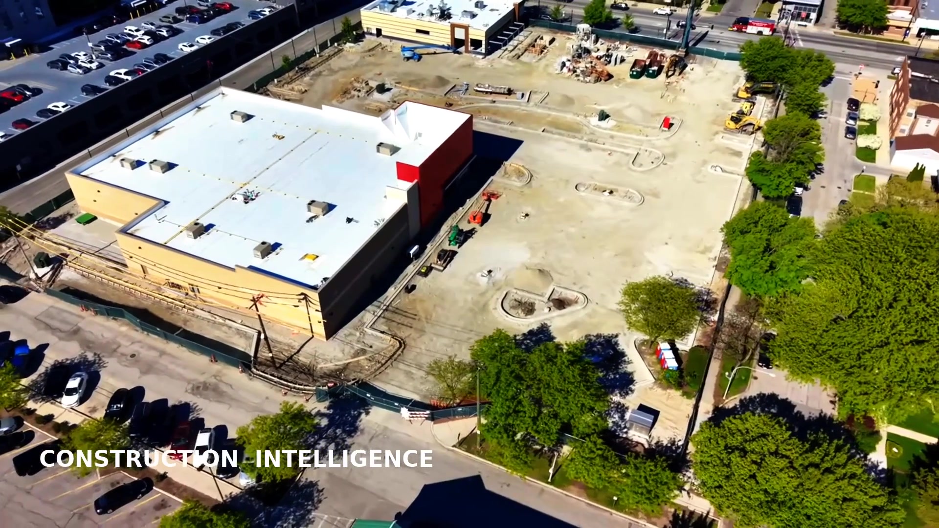
Calculating stockpile or excavation volumes by hand is slow, dangerous, and approximate. Drone photogrammetry measures the same volumes precisely from the air in minutes, ideal for aggregate yards, earthwork, and landfills across Chicagoland. And because each flight is georeferenced, you can overlay surveys week to week for construction progress documentation that lenders, investors, and owners can actually see.
Frequency: Mapping You Can Repeat
A traditional survey is something you commission occasionally because of the cost and time. Drone mapping is cheap and fast enough to repeat on a regular cadence — monthly progress maps, before-and-after earthwork, or seasonal site documentation. That recurring record is invaluable for managing a project and settling disputes about what happened when.
How Drone Mapping Actually Works
A drone mapping survey is not just snapping a few aerial photos. The aircraft flies a programmed grid over your Chicago site, capturing hundreds or thousands of overlapping images from precise positions. Photogrammetry software then stitches those images into a single seamless, georeferenced orthomosaic and reconstructs the terrain as a dense 3D point cloud. When centimeter-level accuracy matters, we place ground control points — surveyed markers on the ground — that anchor the model to real-world coordinates. The result is a measurable digital copy of the site that your team can open in CAD or GIS and pull dimensions, elevations, slopes, and volumes from at any time, long after the crew has left.
Who Benefits Most in Chicagoland
General contractors use drone maps to track progress and verify earthwork against the plan. Architects and engineers use the orthomosaic and 3D model as an accurate basemap for design. Developers and land buyers use it for due diligence on raw parcels. Aggregate yards, demolition firms, and landfills use volumetrics to manage material and billing. Roofing and solar companies use the imagery to scope large facilities. Across the Loop, the suburbs, and the collar counties, any project that needs a fast, current, measurable picture of the ground benefits more from a drone than from a crew limited to walking selected points.
When Traditional Surveying Still Makes Sense
We are straight with clients about the limits: drone mapping does not replace a licensed land surveyor for legal boundary determinations, recorded plats, easements, or work that must be certified to a survey-grade legal standard. Dense tree canopy can also obscure the ground from the air. The best approach pairs the two — a licensed surveyor establishes the legal control and boundaries, and drone mapping supplies the fast, rich, repeatable site data layered on top of it.
Working Around Chicago Airspace
One advantage of hiring a local operator is that we know Chicago's airspace cold. Large portions of the metro sit under the controlled airspace of O'Hare and Midway, where flights require LAANC authorization, and downtown brings its own height and density considerations near the lakefront and the high-rise corridor. A crew that understands these rules schedules flights that are both legal and efficient, instead of discovering a no-fly constraint on the day of the survey. That local knowledge keeps your mapping project on schedule whether the site is in the Loop, out in DuPage or Will County, or up toward Lake County.
Bottom Line for Chicago Site Owners
For planning, design, earthwork, volumetrics, progress tracking, and visualization, drone mapping wins on speed, cost, safety, and the sheer richness of the data — a complete, current model of your entire Chicagoland site. Keep a licensed surveyor for legal boundaries and certified deliverables. Used together, you get the most complete and cost-effective picture of your site from due diligence through closeout.
Frequently Asked Questions
Is drone mapping accurate enough to replace surveying?
For planning, volumetrics, and progress work, yes — centimeter-level with ground control points. For legal boundaries and recorded plats, a licensed surveyor is still required, and drone data complements that work.
How much faster is drone mapping?
A drone captures a multi-acre site in 20 to 45 minutes versus a full day or more for a ground crew, with processed deliverables in a few days.
Can a drone measure stockpile volumes?
Yes. Photogrammetry produces accurate, safe volumetric measurements of piles, excavations, and fill without anyone walking the material.
Is commercial drone mapping legal in Chicago?
Yes. We fly under FAA Part 107 with a certified pilot, obtain LAANC authorization in O'Hare and Midway airspace, and carry full commercial insurance.
What deliverables do I receive?
Georeferenced orthomosaics, digital surface models, contours, 3D point clouds and meshes, volumetric reports, and CAD/GIS-ready exports.
Need a fast, accurate picture of your site? Explore our orthomosaic mapping and 3D modeling services, or visit the Drone Knowledge Center to learn the concepts behind the data.
Request a Free QuoteOr call Dan Gierke, FAA Part 107 pilot, directly at 847-881-4344.