Chicago Drone Service is a locally owned, FAA Part 107 certified drone operation led by remote pilot Dan Gierke. We help organizations across Chicago and the surrounding counties — Cook, DuPage, Lake, Will, and Kane — see their properties, projects, and assets from the air and turn that view into useful, measurable data. Whether you need a single set of marketing photos or a recurring documentation program across multiple sites, our work is built to deliver outcomes, not just pretty pictures.
Because we are based here and know the airspace — including the controlled zones around O'Hare and Midway, LAANC authorizations, and downtown lakefront restrictions — we can plan flights that get you the data you need legally and safely. Below is a breakdown of the industries we serve, what drones actually deliver for each, and where to learn more.
Real Estate & Property
For agents, brokers, property managers, and owners, aerial media makes a listing stand out and tells the full story of a property in a way ground photos cannot. We show lot lines, surrounding amenities, proximity to parks and transit, and the true scale of larger estates and commercial parcels. Listings with drone media tend to attract more clicks and help buyers understand a location faster.
- Aerial stills and cinematic 4K video for residential and commercial listings
- Twilight and golden-hour shots that elevate luxury properties
- Neighborhood and amenity context across Chicago and the suburbs
Learn more on our real estate drone photography and aerial photography pages.
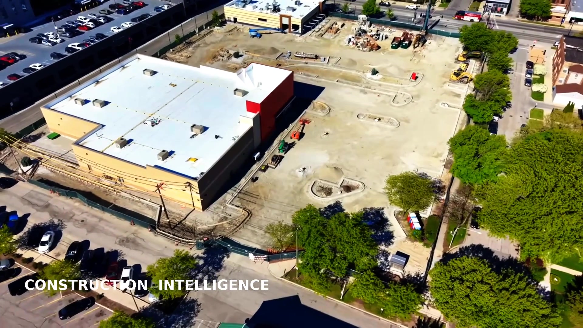
Construction & Development
General contractors, developers, and owners use our flights to document progress, settle disputes, and keep distant stakeholders informed. Regular aerial documentation creates a time-stamped record of every phase, while orthomosaic maps and 3D models give you measurable site intelligence for planning and reporting. Lenders and investors get clear, credible updates without a site visit.
- Scheduled progress documentation and time-lapse
- Volumetric measurements of stockpiles and earthwork
- Lender, investor, and owner reporting packages
See our construction documentation and orthomosaic mapping services.
Architecture & Engineering
Architects and engineers rely on accurate existing-conditions data before they design. Our photogrammetry-based maps and 3D models give design teams a measurable digital record of a site or structure, reducing the need for repeat visits and helping catch issues early. Overhead orthos drop straight into CAD and GIS workflows.
- Existing-conditions surveys and site context imagery
- Measurable 3D models and digital twins for design review
- Geo-referenced maps ready for AutoCAD and GIS
Explore 3D modeling & digital twins and orthomosaic mapping.
Roofing & Solar
Roofing contractors and solar installers use drones to inspect, measure, and document roofs without ladders or lifts. Thermal imaging reveals trapped moisture and insulation gaps, while high-resolution photos document existing damage for estimates and warranties. For solar, radiometric thermal quickly finds underperforming panels and hotspots across an array.
- Roof condition surveys and measured roof reports
- Thermal moisture and heat-loss detection
- Solar panel hotspot and fault inspection
Learn more about thermal drone inspections.
Insurance & Restoration
Adjusters, restoration firms, and property owners use aerial imagery to document loss safely and quickly after storms, fires, or hail. Drones reach damaged roofs and structures that are dangerous to climb, capturing clear, time-stamped evidence that speeds claims and supports accurate scoping. Before-and-after flights document the restoration process from start to finish.
- Storm, hail, and fire damage documentation
- Safe roof and high-structure assessment without lifts
- Time-stamped evidence for claims and scoping
Pair this with thermal inspections and read why drones beat traditional methods.
Commercial & Industrial Facilities & Asset Management
Facility managers and asset owners use recurring drone flights to monitor large roofs, campuses, parking structures, and equipment across Chicago's commercial and industrial corridors. Routine aerial inspections catch problems early — ponding water, membrane failures, corrosion — before they become expensive emergencies, and they build a documented maintenance history.
- Large roof and facade condition monitoring
- Campus, parking, and yard inventory documentation
- Recurring inspection programs with consistent reporting
For ongoing coverage see enterprise programs.
Utilities & Infrastructure
Utility and infrastructure teams use drones to inspect assets that are tall, remote, or hazardous to access on foot. Aerial and thermal imaging documents conditions across spread-out infrastructure quickly, reducing the need to send crews into risky positions and giving engineers detailed visual data to act on.
- Visual and thermal inspection of elevated assets
- Corridor and right-of-way documentation
- Mapping of large or hard-to-reach infrastructure
Related services: thermal inspections and mapping.
Events & Hospitality
Venues, planners, and hospitality brands use aerial coverage to capture the scale and energy of events, resorts, golf courses, and destinations. Sweeping overhead video and stills give marketing teams memorable content, while organizers get documentation of layout, attendance flow, and the full footprint of an event in Chicago and beyond.
- Cinematic event and venue coverage
- Property and amenity showcase media for hospitality
- Layout and footprint documentation
See our aerial photography & video work.
Marketing, Media & Agencies
Agencies, production teams, and in-house marketers bring us in for the aerial angle that elevates a campaign. We deliver broadcast-quality 4K footage and high-resolution stills that fit cleanly into a larger edit, on a fast, dependable timeline. As a local Chicago operator, we can scout and shoot the right locations without out-of-town logistics.
- 4K aerial b-roll and hero shots for campaigns
- Brand, editorial, and product environment imagery
- Reliable turnaround that fits production schedules
Start with aerial photography & 4K video.
Government & Municipal
Municipalities, agencies, and public-works teams use drone data for planning, documentation, and public communication. Geo-referenced maps support infrastructure and land-use decisions, while clear aerial imagery helps explain projects to residents and stakeholders. Every flight follows FAA rules and is fully insured.
- Site and corridor mapping for planning
- Project documentation and public-facing visuals
- Compliant, insured operations near controlled airspace
Visit our knowledge center to understand the data, and areas we serve for coverage details.
Why Teams Across Chicago Choose CDS
No matter the industry, our clients value the same things: FAA Part 107 certification, full insurance, fast 24–48 hour turnaround on most projects, and deliverables you can actually use — measured maps, models, reports, and media. We are local Chicago operators who understand the region's airspace and neighborhoods, so your flight is planned correctly the first time.
Frequently Asked Questions
What industries does Chicago Drone Service work with?
We serve real estate and property, construction and development, architecture and engineering, roofing and solar, insurance and restoration, commercial and industrial facilities, utilities and infrastructure, events and hospitality, marketing and media agencies, and government and municipal teams across Chicago and the surrounding counties.
Do you work with both small businesses and large enterprises?
Yes. We handle one-off shoots for a single Chicago listing or facility as well as recurring, multi-site enterprise programs with predictable cadence, dedicated pilot coverage, and executive reporting.
Are you licensed and insured to fly commercially in Chicago?
Yes. Every flight is conducted by an FAA Part 107 Remote Pilot in Command, and we carry commercial drone liability insurance. We also handle LAANC authorizations for the controlled airspace around O'Hare and Midway.
How fast can I get my deliverables?
Most photo and video projects are delivered within 24 to 48 hours. Maps, 3D models, and thermal reports typically follow within a few business days depending on the size of the site.
Which Chicago areas do you cover?
We cover the City of Chicago plus Cook, DuPage, Lake, Will, and Kane Counties. Any travel beyond our core service area is handled transparently in your quote — see areas we serve for details.
Ready to put your industry's assets in the best possible light? Tell us what you need and we'll recommend the right approach.
Request a Free QuoteOr call us directly at 847-881-4344.