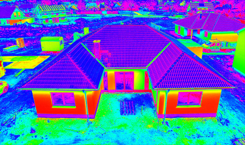
Thermal drone inspection in Chicago uses an aircraft carrying a radiometric infrared camera to read the surface temperature of a roof, wall, solar array, or piece of equipment from the air. Heat loss, trapped water, electrical faults, and failing solar panels — the problems that quietly drain thousands of dollars out of a building every year — are invisible to the naked eye but obvious in infrared. Our thermal drones capture all of them in a single flight, without anyone setting foot on a roof, shutting down a facility, or waiting weeks for a contractor to "come take a look." If you own, manage, insure, or maintain property anywhere in Chicagoland, this is the fastest way to find expensive problems before they find you.
And we don't just hand you raw thermal images. We deliver an annotated report — every anomaly marked, ranked by severity, with a recommended next action — so your facility manager, roofer, or insurance adjuster knows exactly what to fix and what it's costing you to leave it. We serve the City of Chicago plus Cook, DuPage, Lake, Will, and Kane Counties, and as an FAA Part 107 certified, fully insured local operator, we already know the airspace around O'Hare, Midway, and the downtown core.
How Radiometric Thermal Imaging Actually Works
Every surface gives off infrared energy in proportion to its temperature. A radiometric thermal camera measures that energy and assigns a real temperature value to every pixel — not just a pretty false-color picture, but actual data you can quantify and compare. That distinction matters: a basic thermal image tells you "this looks warm," while a radiometric image tells you "this area is 14 degrees warmer than the surrounding membrane," which is what turns a hunch into evidence.
The most revealing surveys happen during the temperature swing after sunset, when a building releases the heat it absorbed during the day. Wet insulation, thermal bridges, and air leaks all shed that stored heat at a different rate than sound, dry material — so they light up clearly in the infrared image. We pair every thermal frame with a matching visual photo so you can see exactly what you're looking at, instead of guessing which warm blob is a skylight and which is a problem.
The Problems We Solve
- Energy bills creeping up year over year — pinpoint heat-loss zones in the building envelope, find missing or wet insulation, and quantify the leak so you can justify the retrofit budget.
- Roof leaks no one can find — locate trapped moisture under the membrane before the ceiling tiles fall in or the warranty expires. We map the wet areas and hand the contractor a literal repair plan, not a guessing game.
- Insurance claims being denied or underpaid — produce time-stamped, geo-referenced thermal evidence of storm damage, water intrusion, or covered loss that holds up with the adjuster.
- Solar panel arrays underperforming — find the exact defective and underperforming modules across thousands of panels in a single morning, with a per-panel report your O&M team can act on.
- Electrical and mechanical equipment running hot — catch failing connections, transformers, motors, and switchgear before they cause the unplanned downtime that kills your quarter.
- Hidden roof damage on commercial buildings you're buying or selling — get a documented thermal baseline before close so it's not a surprise, a renegotiation, or a lawsuit later.
Roof Moisture & Building Envelope Surveys
Flat and low-slope commercial roofs all over Chicago — from West Loop warehouses to North Side multifamily buildings — trap water under the membrane long before it shows up as a stain on someone's ceiling. By the time the leak is visible inside, the wet area underneath is usually far larger, and the repair far more expensive. A thermal survey maps the saturated footprint precisely, so you can cut out and replace only the failed sections instead of tearing off and re-roofing the entire building.
The same physics applies to walls and the full building envelope. Missing insulation, gaps around windows and curtain walls, and air leaks at parapets and penetrations all show up as temperature anomalies. For property owners weighing an energy retrofit, that's the difference between spending the budget where it actually moves the utility bill and spreading it thin across surfaces that were fine to begin with.
Solar Panel Inspections
A single underperforming string can quietly cost a solar array thousands of dollars in lost generation a year, and you'd never know by looking at it from the ground. Thermal drone flights reveal hot spots, cracked cells, bypass-diode failures, and disconnected strings as bright thermal signatures, panel by panel. For a rooftop array on a Cook County distribution center or a ground-mount installation out in Kane County, we can scan the entire site in a fraction of the time a hand inspection takes and deliver a per-module map your operations and maintenance team can work straight off of.
Electrical & Mechanical Anomaly Detection
Loose or corroded electrical connections, overloaded circuits, failing bearings, and overheating motors all announce themselves as excess heat well before they fail outright. Catching them on a scheduled thermal survey lets you plan the repair on your timeline instead of reacting to an emergency outage. For industrial and commercial facilities running on tight production schedules, that predictive view is often the single most valuable thing infrared inspection delivers.
When to Use Thermal Drone Inspection
Thermal is the right tool any time temperature reveals a hidden condition. Common triggers include: a roof that's nearing the end of its warranty or showing interior leaks; an energy audit or retrofit decision; commissioning or annual checkups on a solar array; preventive maintenance on electrical and mechanical systems; due diligence before buying or selling a commercial property; and documenting storm or water damage for an insurance claim. If you're not sure whether your situation calls for thermal, a visual model, or a mapping flight, our why drones overview lays out where each method fits.
Safer and Faster Than a Manual Inspection
Traditional inspections put people on ladders, lifts, and fragile or wet roofs — slow, expensive, and a real safety and OSHA exposure. A drone does the climbing instead, covering the entire surface in one consistent pass with nobody at height. The result is complete coverage, repeatable documentation, and a dramatically lower risk profile. For a side-by-side breakdown of how aerial thermal stacks up against a ground-based handheld camera or a manual lift inspection, see our comparisons on drone vs. manual roof inspection and thermal drone vs. handheld infrared.
Industries We Serve
Thermal drone inspection supports a wide range of Chicago-area clients: commercial and industrial property owners, facility and asset managers, roofing contractors, solar installers and O&M providers, energy auditors, insurance adjusters and restoration firms, and architects and engineers building a condition baseline. Many thermal clients also use our orthomosaic mapping and 3D modeling and digital twin services to document a property completely, and our construction documentation program for ongoing site coverage.
What You Get
Every thermal job includes the radiometric imagery, side-by-side RGB visuals so you can see exactly what you're looking at, and a written report with marked anomalies, severity ratings, and recommended action items. This isn't a folder of pretty heat maps you have to interpret yourself — it's a decision-ready document you can hand to a contractor, an insurer, an asset manager, or a board. Most surveys are flown within days of booking, with reports delivered the same week thanks to our fast 24–48 hour turnaround.
Frequently Asked Questions
What is a thermal drone inspection?
It's an inspection flown with a drone carrying a radiometric infrared camera that measures the surface temperature of a roof, wall, solar array, or equipment from the air. Temperature differences reveal trapped moisture, missing insulation, heat loss, and overheating components that an ordinary camera can't see — and the drone does it without anyone climbing on the roof.
How does it find a roof leak no one else can?
Wet insulation under a roof membrane holds and releases heat differently than dry material. After sunset, the saturated areas glow warmer in the infrared image, mapping the exact footprint of trapped moisture so your roofer can make a targeted repair instead of replacing the whole roof.
Is it really safer than sending someone up?
Yes. The drone does the climbing, so there are no ladders, lifts, or workers walking a fragile or wet roof. You get complete, documented coverage of the entire surface while removing the fall risk and OSHA exposure of a manual inspection.
Do you serve the Chicago suburbs as well as the city?
We cover the City of Chicago plus Cook, DuPage, Lake, Will, and Kane Counties — including Naperville, Schaumburg, Evanston, Oak Brook, Aurora, and Joliet. As a local Part 107 operator we file LAANC authorizations for controlled airspace near O'Hare and Midway when needed.
How accurate are the temperature readings?
Because we use radiometric cameras, every pixel carries a real temperature value, and we capture surveys under the right conditions (typically the post-sunset cooldown) to maximize contrast. We also pair every thermal frame with a matching visual photo so anomalies can be verified, not guessed at.
How soon will I have my report?
Most thermal surveys are scheduled within a few days, and annotated reports are typically delivered the same week — often within 24 to 48 hours of the flight.
Your building is telling you what's wrong with it. We translate.
Request a Free QuoteOr call Chicago Drone Service directly at 773-213-6859 to schedule a thermal survey.